


montee St Jacques

verozerr
User
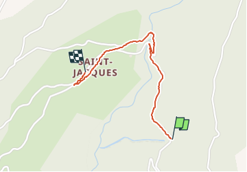

Length
1.3 km

Max alt
1434 m

Uphill gradient
40 m
Km-Effort
1.9 km

Min alt
1376 m

Downhill gradient
46 m
Boucle
No
Creation date :
2022-07-14 09:04:37.173
Updated on :
2022-07-14 09:43:36.588
38m
Difficulty : Easy

FREE GPS app for hiking
 SityTrail
IGN / Geographical institutes
SityTrail Plus
The world is yours!
About
Trail Walking of 1.3 km to be discovered at Auvergne-Rhône-Alpes, Savoy, La Tour-en-Maurienne. This trail is proposed by verozerr.
Description
st j
Positioning
Country:
France
Region :
Auvergne-Rhône-Alpes
Department/Province :
Savoy
Municipality :
La Tour-en-Maurienne
Location:
Le Châtel
Start:(Dec)
Start:(UTM)
294954 ; 5020993 (32T) N.
Comments